
We could find only one other reference to boating this section, a group of boaters ran the section in September of 2010 with water levels around 300 cfs. Since much of what they ran would look and act completely different at the higher water flows, we weren't really sure what to expect! Grant and Kirk and I had seen different sections of the river from different points, but there are quite a few spots where gorges or overgrown brush make it difficult to see what is happening from the trail, or even when bushwacking and trying to see the river. It would be a true adventure!
We left Bend late afternoon on July 3 for the six hour drive to Minam. Rolling in about 11pm, we crashed on the lawn of the Minam River Motel (Grant's new purchase this year). In the morning we hemmed and hawwed about what to bring...hammocks? beer? Our 13 mile hike from Buck Creek Trailhead would take us over a 8,000' pass with thousands of feet of elevation gain and loss, so we tried not to make our packs unbearably heavy. It didn't work. They were still heavy.
Grant met us with his load including a very nice camera, tripod and gopro. We would have some great footage of this trip! Our point-and-shoot camera usually stays in our PFDs during the rapids. It's hard to take pictures and paddle at the same time.
Lottie, Grant's wife, shuttled us to the trailhead, and after sweating to get our packs on, we began the slow assent to Burger Pass.
 |
| Kirk and Grant on their way up the pass. |
 |
| Kirk finds snow at Burger Pass |
 |
| Grant enjoys the view |
 |
| Stunning granite mountains |
 |
| Crossing Elk Creek |
 |
| Since wearing barefoot shoes, I just walk through the water. |
 |
| Camp near the confluence of Elk Creek & Minam River |
 |
| Ready the boats! |
 |
| This is the life! |


Mid afternoon we came around a corner to see our first horizon line, a fairly large ledge drop of about 15' consisting of three 5' ledges. After a few minutes I decided to walk around this one, or more aptly described, hopped over rocks above the rapid and ducked under trees and pushed through brush and then scrambled some more...until I was below and could set safety for Kirk who decided to run the rapid.
 |
| View of the rapid from above |
By early evening we were getting tired; the portages had taken a toll on our bodies (continuing at about 1 per mile) and our boats and the long hours on the river had me dreaming of dinner and rest. Every time it gorged up we knew there was a good rapid, and some times a log in it. LOTS more eddy hopping and boat scouting.
We were at mile 10ish of a 14-16 mile day. After passing the Little Minam River and Big Burn flat (A NICE spot where we had camped last year), we figured we could go about four more river miles before taking out above the Minam Falls to camp at a grassy meadow.
We floated, the water was quite calm and serene...until we turned a corner above a short gorge section, and another horizon line. A fallen tree had blocked the entrance to the gorge, and Grant bushwacked over to see if we had enough room to squeeze our boats through. After going Grizzly Adams on some tree-branches, he returned and reported that we would be able to pass, go Grant! Apparently we were in for 2 ledge drops and a short rapid with a big pool.
 |
| If I really had been scouting I would have been ALOT more nervous about what was to come... |
 |
| Nah, can't see the massive water ahead |
We all regathered below the gorge with a renewed sense of exhilaration and excitement. We surely only had a short way to go before camp, so set off on the last few miles...only to encounter yet another gorge and possible log portage.
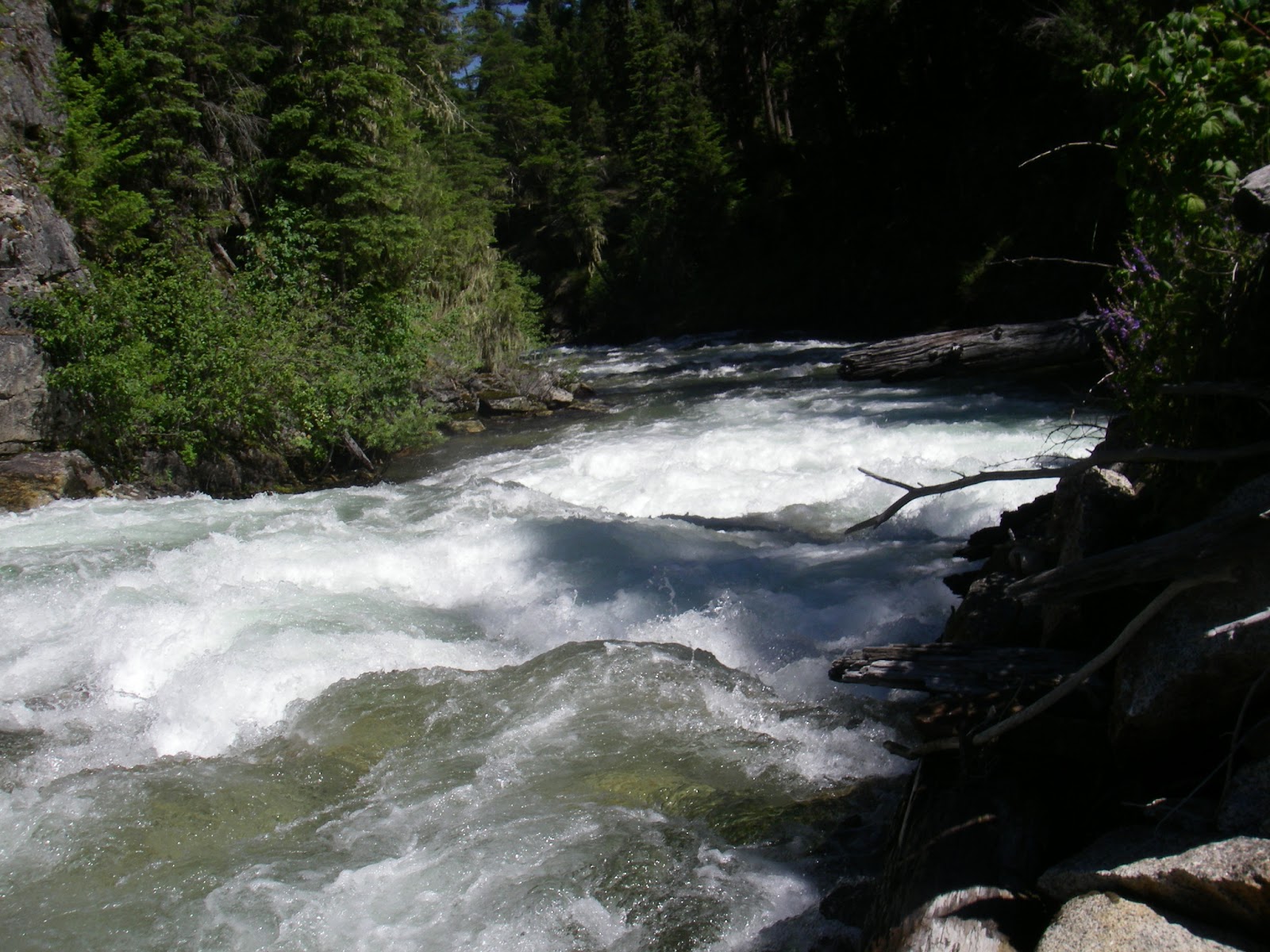
Kirk and Grant got out to investigate...after bushwacking a good 1/8 mile they saw the log was passable and the rapid, a good class III boulder garden with an eddy on the corner. Um, that's how it started, the class III built into a class IV boulder garden ANOTHER EXTREMELY DEMANDING (scarey - my words) section ending in another horizon line.
What began as mild whitewater turned into massive hydraulics as we negotiated boulders in continuous 4-6' pour-overs, this truly is a 100'-per-mile-section as google earth would suggest. At the bottom we were all suprised and I was shaken-up by the experience. But no carnage, and after I regained my breath and pulse before going over the next horizon line, we only had to descend a short and steep rapid before we were in the clear for the rest of the float to camp.
 |
| Below the last rapid of the day after a monstrous section |
The large meadow where we made our second night's camp was above the quite intimidating Minam Falls (what used to also be a splash damn, or a temporary wooden dam used to raise the water level in streams to float logs downstream to sawmills). Though Minam Falls only has remnants of a splash damn, down the corner there are still two river-wide logs from two other splash damns making deadly river-wide low-head damns/holes.
It was practically dark by the time we ate dinner and I turned in completely exhausted.
In the morning light I could almost forget my fear at the last few sections the day before, but not completely. I decided to walk the trail around the final four miles of "unknown" river and gorges before the water widens out and is much calmer at Red's. I was beaten up and bloody and enjoyed the hiking.
The water level was down to about 700 cfs, and the guys portaged this section; running Minam Falls isn't out of the question, but at this water level with three river-wide holes at the bottom of the falls you might not come out unscathed ... then getting out in time before the log splash-damns around the corner might be a much hairier situation.
The portage was easy with a game/hiking trail the whole way.
 |
| Minam Falls |


 |
| Looking back towards Minam Falls |
 |
| Two river-wide logs, remnants of the old splash-damns |

We floated to the far end of the meadow and took out near the Minam River Lodge. With boats in the shade of the mid-day sun, we walked up to the lodge with hopes of cold beer.


A couple of Pale Ales and IPA's later, we left the lodge to get in a few more miles before dark.


The water was splashy and continuous class II, and after a while Grant and I switched boats. He hadn't paddled an Alpacka before, and he was paddling a self-bailing Feathercraft BayLee boat. I was intrigued by the self-bailing feature as the velcro on my Lama had become matted with moss and debris from the many portages where we were pushing and falling through dense brush; the velcro on my spray skirt was not remaining shut through the rapids and I had to constantly pull over to dump out the boat.
 |
| Grant tries out the Alpacka |
We made camp on some prime river-front property...granted the flat spots were few and far between, but we had a long beach of rocks and a great view of the water.

We woke on our last morning and loaded up the boats for one long stretch directly to the door of the Minam River Motel. The water was calm and the day was a big improvement over last year when we had rain for most of the section.

 |
| We paced the horseback rider for some time. |


 |
| Kirk surfs |
 |
| Approaching Minam River Motel |
Since we were done mid-afternoon, Kirk and I drove up the Lostine River and found a pristine camp on the water and proceeded to relax in style most of the rest of the day.

Nice! I experienced delicious horrified shivers reading about your class IV foamy near-deaths.
ReplyDeleteWhat's a proper adventure without a few near-death experiences? But really, we were all capable of running that water, I've just decided it isn't FUN. I think the guys had a blast through it all.
ReplyDeleteThanks for the awesome trip report. I'm considering going down this section late June. There are a couple people who want to join who are not strong kayakers and would want to portage the class III's. Am I right from reading your account that there are only 3 or 4 class III's and they are pretty easy to hike around?
ReplyDeleteNot at all, the top 20 miles are non stop class III that grow to class IV in size with very few eddies, logs everywhere and one two part class V goorge. The Portage are horrible. The bottom 20 miles are easy class II to III (below reds ranch). I personally would not go above red unless everyone is a solid class IV boater who can boat scout and catch every micro eddy without hesitation.
ReplyDeleteGood to know. Thanks so much for the quick response, and great info.
ReplyDeleteThe bottom 20 (or 22ish I think) are well worth doing as well. It is a 9 mile hike in to reds over the pass or 22 miles upstream on a very good trail from the take out or you can hire a plane to fly you into Reds Ranch (well worth a meal stop or overnight stay but you need to reserve a head of time).
DeleteGrant Ritchie at the Minum Store (also your take out) could give you some names of pilots as far as the airplane option or possibly a car shuttle.
The upper is also worth doing but I would go in there with a strong crew and be prepared to do a lot of bushwhacking portages on blind corners, about one per mile for the first 20 miles.