Hmmm, it's been over four months since we've been packrafting.
If I'm honest with myself, our trip down the Minam River in July has a lot to do with the gap. It was beautiful, challenging and exhilarating, and I got scared by some of the bigger water.
Time to get in the boat.

Nov 6, 2013
Nov 3, 2013
Beyond Packrafting...Rafting the Lower Deschutes
For a while I've been wanting to start writing about some of our other trips, we get out in so much more than packrafts, but is this blog the right place? Should I start a separate site for adventures other than packrafting? Or include all our trips here? Not sure quite yet, so for the mean time I'll include them here.
For Thanksgiving we decided to yet again head for the water. Last year you may remember our packrafting trip on the North Fork of the John Day River, it was complete with Turkey and pie and dropping water levels.
The year before we rafted the Lower Deschutes River from Warm Springs to Maupin, and we decided to complete the journey and raft from Maupin (for those familiar with the area we actually put on below Shears Falls at Buck Hollow) to the Columbia River.
As two years before, we were joined by two good thru-hiking friends, Speed Stick (Mary) and Luigi (John). Instead of all piling on one raft this year, Kirk and I decided to borrow a friend's Super Puma.
 |
| That is one sexy boat. |
We had been talking about getting one of these bad boys...for many reasons. One, together we could boat some bigger water than I'd like to solo boat...Kirk started out the pitch by showing me people R2ing waterfalls and Class V water. I would love to boat more stuff like that, but don't know if my packrafting skills will progress to that level (or if I want them too...) but with Kirk in the boat directing our paddle strokes I could see us running A LOT more stuff. Two, we could outfit this boat for longer trips and even set it up as a mini oar-rig. (And we probably wouldn't have to carry other people's stuff!). Three, we only have a 14' bucket boat right now. Four, this can go creeking!
We put on the river at Buck Hollow, approximately 40 river miles from the Columbia River. We had a 10 lb turkey, pumpkin pie, mashed potatoes, stuffing, cranberry sauce, gravy, green beans, rolls, wine and enough beer to float us for the next four days. Mary was watching Bella, our friend's black lab, so she came along for the ride.
 |
| Beer and dogs make good companions on the river. |
That morning we dropped into the Deschutes River canyon amid a freezing fog...once the sun hit us we warmed up a bit, but the air was cold and our late fall sun didn't break through the thousands of feet of canyon walls very often.
 | |||
| At noon we still didn't have much sun in the canyon. |
 |
| Frozen waterfalls marked our way. |
We made camp the first night and set to work heating up the Turkey and fix'ns. YUM.
 | |
| Mary and John dig in. |
 |
| Thats the stuff! |
We woke to a bitter cold morning, everything was frozen and putting on the water when the sun was still behind the canyon walls wasn't an exciting prospect. But, we donned dry suits and sipped hot coffee and it got better.
Our float was fairly mellow. Most of the rapids of Class II & III would be the following two days, so we floated along and enjoyed the sponsored goods Mary brought (she is the only girl I know sponsored by BEER. Thanks to Hop Valley out of Eugene, OR we had plenty of bevys all weekend.)
 |
| The impressive canyon continues |
 |
| Hop Valley Rocks! |
Camp the second night was a cozy affair, a fire kept us warm into the darkness, but the temps were warmer than the night before and all were happier for it.
We cooked up a pound of bacon and a dozen eggs in the morning to get us fueled up for another chilly day on the water.
 |
| Camping in the kitchen is only a good idea if you are an early riser.... |
More boating, more water. Kirk and I were enjoying the R2ing in the Super Puma....getting closer to wanting one of our own.
 |
| Super Puma on the move. |
 |
| We were the only boats on the river. |
 |
| Toasting a great trip. |
Our last camp was a bumpy burned-out affair, a fire this year left much of the lower river corridor scorched.
 |
| The only flat spot around. |
Our final day saw a few rapids and I have to say, the Super Puma did quite well. We'll be seriously thinking about this boat in the future.
The terrain got milder and we started to see the wind mills that trademark much of the Columbia Gorge today.
 |
| The canyon gets milder. |
We took out about noon and finished with cold turkey sandwiches. Yet another awesome river trip with good friends.
Super Puma in our future? I hope so.
Oregon Desert Trail
Last summer I met up with my good friend Sage Clegg as she attempted the first continuous trip on the new Oregon Desert Trail.

The Oregon Desert Trail (ODT) is a 800 mile hiking route that starts near Bend and ends at Lake Owyhee State Park, near the Snake River in Idaho.
Here is an excerpt from my journal during that visit:
As we drove down the two-track dirt road towards Schoolhouse Spring near the base of Oregon Canyon, the headlights bounced off curious jack rabbits and hopping field mice. Dusk brought little relief from the heat, and as we rolled up to our stopping place for the night, cows ran in all directions to escape the path of the vehicle.
We were attempting to meet Sage on the Oregon Desert Trail with gifts of fruit, cold beer and some good company. A strong wind and bright moonlight led to a restless night's sleep, but when Sage walked up at 6:30 the next morning we sprang up ready to hear about her adventure.
Apparently Oregon Canyon had been a bushwhack fest and her legs were red from hundreds of scratches; the brush was not forgiving. After some hot coffee and berries, we donned packs for the 12ish mile hike to Highway 95 where Kirk would meet us and take us into McDermitt for some relief from the sun.
The day was scorching, but I was excited to hike. Even though we just met a few years ago, Sage and I share many through-hiking experiences. Tales of our different Appalachian Trail, Pacific Crest Trail and other hiking adventures helped the hot miles pass. We talked of the future of the ODT and the roll we have to play, and when we left the easy hiking of the two-track road for the cross-country miles, we played dodge the sagebrush and hop the fence.
Close to the highway we came upon a cool and clear cow tank and couldn't resist splashing around to escape the 100-plus-degree day. Water was plentiful in this flat walk, thanks to the ranchers and their numerous cow tanks. While it could be scummy with green algae or seeping into the ground in a muddy pool, we both were grateful for the appearance of water. We had both been on desert hikes before, on my Arizona Trail hike I often had to drink from muddy water full of cow pies, but that was infinitely preferable to no water. Sage had experienced all sorts of water sources on her Continental Divide Trail and Grand Enchantment Trail; any water is good water!

Kirk met us at the road and we sped to the Oregon/Nevada border town of McDermitt. Lunch was in the dark Say When Casino & Cafe on the Nevada side, and after she retrieved her food drop box and gift of cookies from Adam's mom, we drove to Anderson Crossing.
At Anderson Crossing (two day's walk from where the ODT meets Hwy 95) we planned to leave a food cache for Sage, and tonight would camp on the banks of the West Little Owyhee River. The crossing marks a 180-degree shift in trailtread, as from this point to the end of the trail Sage will be walking in the river canyon or along the rim of the dramatic geological wonder.
It was SO HOT, so we plopped camp chairs in the water and popped open a few beers. Little brook trout were plentiful and beaver activity had dammed up the river right above where we sat soaking our feet.
Kirk and I are packrafters and even though the waterway was narrow and choked with willows at places, decided a pack-rafting alternate would be a great addition to this section of the ODT.
In the morning the sun brought the heat back in full-force. Sage arranged and rearranged her gear; as she wasn't sure how efficient her travel would be though the canyon, she was packing extra food and decided to borrow Kirk's larger Granite Gear Vapor Trail pack (a favorite among many through-hikers for its light weight -- 2 lbs 5 oz -- and large capacity -- 59 liters or 3,600 cubic inches).
We dug a hole in the ground and buried her food, pilling it high with rocks to deter any animals.

We returned to McDermitt, where Sage checked into the motel for a true 0 day (no hiking) to rest her feet and prepare for the next section. After milkshakes and double-bacon cheeseburgers, we said our goodbyes and headed back to Bend.
The Oregon Desert Trail (ODT) is a 800 mile hiking route that starts near Bend and ends at Lake Owyhee State Park, near the Snake River in Idaho.
Here is an excerpt from my journal during that visit:
We were attempting to meet Sage on the Oregon Desert Trail with gifts of fruit, cold beer and some good company. A strong wind and bright moonlight led to a restless night's sleep, but when Sage walked up at 6:30 the next morning we sprang up ready to hear about her adventure.
Apparently Oregon Canyon had been a bushwhack fest and her legs were red from hundreds of scratches; the brush was not forgiving. After some hot coffee and berries, we donned packs for the 12ish mile hike to Highway 95 where Kirk would meet us and take us into McDermitt for some relief from the sun.
The day was scorching, but I was excited to hike. Even though we just met a few years ago, Sage and I share many through-hiking experiences. Tales of our different Appalachian Trail, Pacific Crest Trail and other hiking adventures helped the hot miles pass. We talked of the future of the ODT and the roll we have to play, and when we left the easy hiking of the two-track road for the cross-country miles, we played dodge the sagebrush and hop the fence.
Close to the highway we came upon a cool and clear cow tank and couldn't resist splashing around to escape the 100-plus-degree day. Water was plentiful in this flat walk, thanks to the ranchers and their numerous cow tanks. While it could be scummy with green algae or seeping into the ground in a muddy pool, we both were grateful for the appearance of water. We had both been on desert hikes before, on my Arizona Trail hike I often had to drink from muddy water full of cow pies, but that was infinitely preferable to no water. Sage had experienced all sorts of water sources on her Continental Divide Trail and Grand Enchantment Trail; any water is good water!
Kirk met us at the road and we sped to the Oregon/Nevada border town of McDermitt. Lunch was in the dark Say When Casino & Cafe on the Nevada side, and after she retrieved her food drop box and gift of cookies from Adam's mom, we drove to Anderson Crossing.
At Anderson Crossing (two day's walk from where the ODT meets Hwy 95) we planned to leave a food cache for Sage, and tonight would camp on the banks of the West Little Owyhee River. The crossing marks a 180-degree shift in trailtread, as from this point to the end of the trail Sage will be walking in the river canyon or along the rim of the dramatic geological wonder.
It was SO HOT, so we plopped camp chairs in the water and popped open a few beers. Little brook trout were plentiful and beaver activity had dammed up the river right above where we sat soaking our feet.
Kirk and I are packrafters and even though the waterway was narrow and choked with willows at places, decided a pack-rafting alternate would be a great addition to this section of the ODT.
In the morning the sun brought the heat back in full-force. Sage arranged and rearranged her gear; as she wasn't sure how efficient her travel would be though the canyon, she was packing extra food and decided to borrow Kirk's larger Granite Gear Vapor Trail pack (a favorite among many through-hikers for its light weight -- 2 lbs 5 oz -- and large capacity -- 59 liters or 3,600 cubic inches).
We dug a hole in the ground and buried her food, pilling it high with rocks to deter any animals.
We returned to McDermitt, where Sage checked into the motel for a true 0 day (no hiking) to rest her feet and prepare for the next section. After milkshakes and double-bacon cheeseburgers, we said our goodbyes and headed back to Bend.
As
we drove down the two-track dirt road towards Schoolhouse Spring near
the base of Oregon Canyon, the headlights bounced off curious jack
rabbits and hopping field mice. Dusk brought little relief from the
heat, and as we rolled up to our stopping place for the night, cows ran
in all directions to escape the path of the vehicle.
We were attempting to meet Sage on the Oregon Desert Trail with gifts of fruit, cold beer and some good company. A strong wind and bright moonlight led to a restless night's sleep, but when Sage walked up at 6:30 the next morning we sprang up ready to hear about her adventure.
Apparently Oregon Canyon had been a bushwhack fest and her legs were red from hundreds of scratches; the brush was not forgiving. After some hot coffee and berries, we donned packs for the 12ish mile hike to Highway 95 where Kirk would meet us and take us into McDermitt for some relief from the sun.
The day was scorching, but I was excited to hike. Even though we just met a few years ago, Sage and I share many through-hiking experiences. Tales of our different Appalachian Trail, Pacific Crest Trail and other hiking adventures helped the hot miles pass. We talked of the future of the ODT and the roll we have to play, and when we left the easy hiking of the two-track road for the cross-country miles, we played dodge the sagebrush and hop the fence.
Close to the highway we came upon a cool and clear cow tank and couldn't resist splashing around to escape the 100-plus-degree day. Water was plentiful in this flat walk, thanks to the ranchers and their numerous cow tanks. While it could be scummy with green algae or seeping into the ground in a muddy pool, we both were grateful for the appearance of water. We had both been on desert hikes before, on my Arizona Trail hike I often had to drink from muddy water full of cow pies, but that was infinitely preferable to no water. Sage had experienced all sorts of water sources on her Continental Divide Trail and Grand Enchantment Trail; any water is good water!
Kirk met us at the road and we sped to the Oregon/Nevada border town of McDermitt. Lunch was in the dark Say When Casino & Cafe on the Nevada side, and after she retrieved her food drop box and gift of cookies from Adam's mom, we drove to Anderson Crossing.
At Anderson Crossing (two day's walk from where the ODT meets Hwy 95) we planned to leave a food cache for Sage, and tonight would camp on the banks of the West Little Owyhee River. The crossing marks a 180-degree shift in trailtread, as from this point to the end of the trail Sage will be walking in the river canyon or along the rim of the dramatic geological wonder.
It was SO HOT, so we plopped camp chairs in the water and popped open a few beers. Little brook trout were plentiful and beaver activity had dammed up the river right above where we sat soaking our feet.
Kirk and I are packrafters and even though the waterway was narrow and choked with willows at places, decided a pack-rafting alternate would be a great addition to this section of the ODT.
In the morning the sun brought the heat back in full-force. Sage arranged and rearranged her gear; as she wasn't sure how efficient her travel would be though the canyon, she was packing extra food and decided to borrow Kirk's larger Granite Gear Vapor Trail pack (a favorite among many through-hikers for its light weight -- 2 lbs 5 oz -- and large capacity -- 59 liters or 3,600 cubic inches).
We dug a hole in the ground and buried her food, pilling it high with rocks to deter any animals.
We returned to McDermitt, where Sage checked into the motel for a true 0 day (no hiking) to rest her feet and prepare for the next section. After milkshakes and double-bacon cheeseburgers, we said our goodbyes and headed back to Bend.
It was great to be able to meet her in the midst of the hike and set her up for the next section. I'm excited to see the results of Sage's hike for when I tackle a through-hike of the ODT in a few years
- See more at: http://onda.org/where-we-work/oregon-desert-trail/blog/on-to-mcdermitt#sthash.U7RYtXVc.dpuf
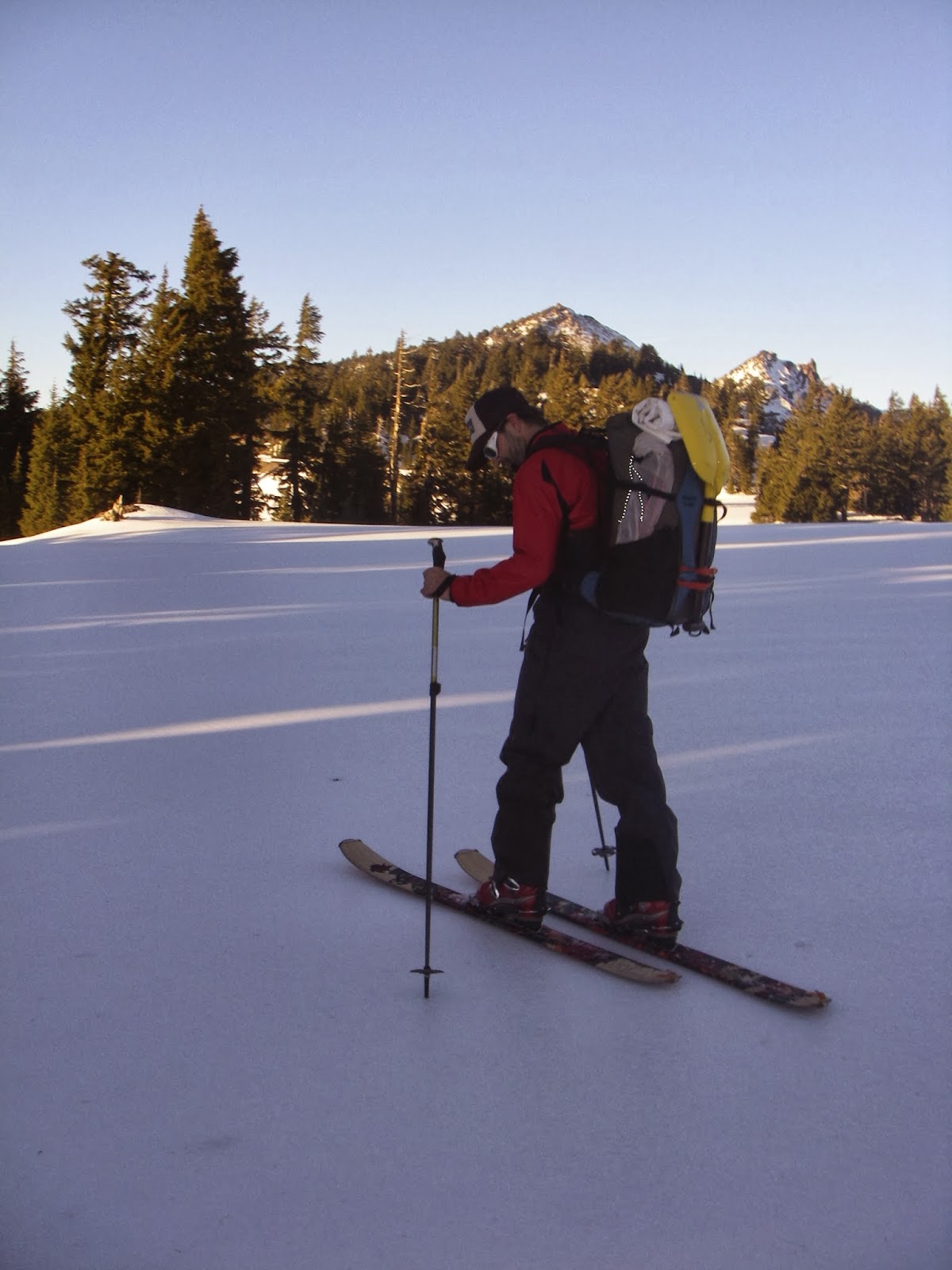
Crater Lake Rim Ski Shut-out
We have intended to ski the rim of Crater Lake
several times over the past few years, but the weather often has other
ideas. Perhaps that is part of the allure. The feat, while not overly
technical, can be thwarted by not enough snow, too much snow, high
winds, ice, avalanche conditions and even visibility. Why ski around the
rim of the deepest lake in North America if you can't see it?
The ski route circumnavigates the 1,949 foot-deep-lake by following the rim road approximately 30 miles.
I'm incredibly fascinated about the lake's origins. The 12,000 foot Mount Mazama once existed where the lake is today, almost 6,000 feet higher than the rim!
6,000 - 8,000 years ago the mountain erupted with so much power that the ash and pumice from the event can be found covering nearly all of Oregon, Washington, Northern California, Idaho, Western Montana, and parts of Utah, Nevada, Wyoming, Alberta, British Columbia, and Saskatchewan.
Mount Mazama collapsed into itself and created the 5 x 6 mile wide caldera. The lake has no inlets or tributaries, so is incredibly pure.
Needless to say, your mind has a lot of incredible beauty and history to chew on while traveling around the rim.
An unseasonably warm and dry November and December had the rim snow at about 9" (with dirt patches showing) when we arrived the day after Christmas. An ice storm the week before had blanketed Oregon with an unsavory icy layer, but I had been monitoring the weather reports a few weeks before the trip and saw that temps were reaching the 50s up there. Maybe we would encounter a slushy mess instead of ice? Anyway, we decided to drive down and attempt the trip.
Crater Lake is about a two hour drive from Bend, and as we pulled up mid-afternoon we were still encountering ice on the road...hmmm, not a great sign!
Winter trips to the lake are free: no entry fees, no parking fees, no backcountry permit fees, but the park rangers do have you get a backcountry permit. While at the ranger office we were strongly advised against our trip. Apparently two rangers had gone out on x-country skis a few days before and made it less than 6 miles before turning around; the rim was bullet ice.
Grrr, would we be unable to make our trip? Kirk and I decided to ski out and try a night on the rim, we admitted we probably wouldn't make it the whole way around, but there was no way we would turn around, and they didn't say we couldn't go...
Besides, we would have touring skis with metal edges, and skins if things got dicy.
Most tourists had been walking around in snow shoes, and about a mile of the trail from parking lot on the Southern edge of the rim was quite trampled.
We loaded up our packs and started sans skins, however before we even got 100 feet from the car we realized skins were necessary if we weren't going to plow over the tourists; we didn't want to stay in the narrow snow shoe trail with so many people coming and going, and once we stepped onto the ice there was no digging in with edges or easy stopping.
Ok. Skins on, we skiied.
We skied far enough to make camp before the sun set...and it was pretty obvious we wouldn't be skiing around the rim. The ice was much much to thick and it really wasn't fun! Even with skins on the going was dicy at times.

The next morning we drank our hot coffee while packing up, having decided to drive to the coast for the rest of our days off.


Crater Lake, we will meet again.
 |
| Photo from Wikipedia |
I'm incredibly fascinated about the lake's origins. The 12,000 foot Mount Mazama once existed where the lake is today, almost 6,000 feet higher than the rim!
6,000 - 8,000 years ago the mountain erupted with so much power that the ash and pumice from the event can be found covering nearly all of Oregon, Washington, Northern California, Idaho, Western Montana, and parts of Utah, Nevada, Wyoming, Alberta, British Columbia, and Saskatchewan.
Mount Mazama collapsed into itself and created the 5 x 6 mile wide caldera. The lake has no inlets or tributaries, so is incredibly pure.
Needless to say, your mind has a lot of incredible beauty and history to chew on while traveling around the rim.
An unseasonably warm and dry November and December had the rim snow at about 9" (with dirt patches showing) when we arrived the day after Christmas. An ice storm the week before had blanketed Oregon with an unsavory icy layer, but I had been monitoring the weather reports a few weeks before the trip and saw that temps were reaching the 50s up there. Maybe we would encounter a slushy mess instead of ice? Anyway, we decided to drive down and attempt the trip.
Crater Lake is about a two hour drive from Bend, and as we pulled up mid-afternoon we were still encountering ice on the road...hmmm, not a great sign!
Winter trips to the lake are free: no entry fees, no parking fees, no backcountry permit fees, but the park rangers do have you get a backcountry permit. While at the ranger office we were strongly advised against our trip. Apparently two rangers had gone out on x-country skis a few days before and made it less than 6 miles before turning around; the rim was bullet ice.
Grrr, would we be unable to make our trip? Kirk and I decided to ski out and try a night on the rim, we admitted we probably wouldn't make it the whole way around, but there was no way we would turn around, and they didn't say we couldn't go...
 |
| Wizard Island |
Most tourists had been walking around in snow shoes, and about a mile of the trail from parking lot on the Southern edge of the rim was quite trampled.
We loaded up our packs and started sans skins, however before we even got 100 feet from the car we realized skins were necessary if we weren't going to plow over the tourists; we didn't want to stay in the narrow snow shoe trail with so many people coming and going, and once we stepped onto the ice there was no digging in with edges or easy stopping.
Ok. Skins on, we skiied.
 |
| Kirk adjusting the skins on his new Voile Charger BC skis |
 |
| I'm wearing Kirk's Karhu XCD Guide Skis, and yep, that's the road showing through! |
 |
| Hmmm, the ice is so thick we can't even make tracks. |
 | ||
| We found a scenic spot to set up our tent. |
 | |||
| And enjoyed a beer on the rim for the sunset. |
The next morning we drank our hot coffee while packing up, having decided to drive to the coast for the rest of our days off.
 |
| The clouds had moved in over night |
Crater Lake, we will meet again.
Shelter with a View
We've had backcountry skiing on the mind this winter, but some crazy weather patterns didn't bring enough snow to do much until a few weeks ago, but then the avalanche danger has been uber sketchy.
Well before we could know what this winter would bring we went on a search for a cabin rental for us and a few friends. Last year we spent a few days at the Hemlock Cabin at the base of Mt. Bailey, but when looking this year the weekends were already booked.
We had designs to head to the yurts in the Wallowa Mountains, but the drive was just too far for a quick weekend trip.
So we looked to Mt. Hood. Kirk and I had been to the Tilly Jane cabin before, and its perch on the north-eastern side of the mountain near tree-line could offer up some sweet skiing in the right conditions.
Unfortunately the conditions the week of the trip were extreme. Several reports were specifically asking skiers to not go into the backcounty around Hood, and after staring at the Northwest Avalanche Center forecast for long enough, we decided to go somewhere else.
Where to???
We decided to check out Mountain View shelter on the west side of Three Finger Jack.


It was a beautiful weekend to be in the backcountry, even if the snow conditions sucked.
Well before we could know what this winter would bring we went on a search for a cabin rental for us and a few friends. Last year we spent a few days at the Hemlock Cabin at the base of Mt. Bailey, but when looking this year the weekends were already booked.
We had designs to head to the yurts in the Wallowa Mountains, but the drive was just too far for a quick weekend trip.
So we looked to Mt. Hood. Kirk and I had been to the Tilly Jane cabin before, and its perch on the north-eastern side of the mountain near tree-line could offer up some sweet skiing in the right conditions.
Unfortunately the conditions the week of the trip were extreme. Several reports were specifically asking skiers to not go into the backcounty around Hood, and after staring at the Northwest Avalanche Center forecast for long enough, we decided to go somewhere else.
Where to???
We decided to check out Mountain View shelter on the west side of Three Finger Jack.
The shelter can be quite popular due to the amazing 360 degree views. It sits on a ridge line with snow-topped peaks all around; the shelter is quite a change from your average dark hole of a cabin. Lots of windows, sleeping platforms and an efficient wood stove.
 |
| Not a bad day for a tour |
 |
| Looking back towards the Three Sisters |
 |
| Why not build a snow couch? |
 |
| When the stove is fired up it gets quite toasty inside |
We hope to explore more cabins for winter ski trips over time; I'm particularly interested in several of the fire tower look-outs in the area.
When in doubt, go somewhere new!
Sep 16, 2013
No shortage to the adventures
It has been a bit of a "dry" summer for us lately. Oh the rivers are running, albeit they are all pretty low this time of year, but we've been caught up in a bit of backpacking, sailing and road-tripping, all things that impact our packrafting time!
But the cooler temps are around the corner and snow in the mountains will mean water in the rivers. This will be the first winter I will have a dry suit, so we are looking forward to adding some variety to our ski weekends this year.
Oh man, life is rough in Central Oregon!
 |
But the cooler temps are around the corner and snow in the mountains will mean water in the rivers. This will be the first winter I will have a dry suit, so we are looking forward to adding some variety to our ski weekends this year.
Oh man, life is rough in Central Oregon!
Aug 13, 2013
Independence on the Minam River
Independence on the Minam River from Renee Patrick on Vimeo.
Muscling around iMovie in one of the poorest designed multi-media programs I have ever used (maybe as a graphic designer I expect more), we present our Minam River trip over July 4.
We didn't get footage from some of the bigger water, but that can wait for next year's trip!
Jul 15, 2013
Minam River - Round 2! A Very American 4th
When Kirk and I traveled to the Minam River in the Wallowa Mountains last June, we hit the spring snow melt and were faced with flows around 3,500 cfs...and in effect did not do as much boating as originally planned. When Grant Ritchie, a fellow packrafter and owner of Minam Raft Rentals contacted us about packrafting the Minam again, but from higher in the drainage, (a trip of 40 river miles) we jumped at the chance. In his estimation hitting flows at about 600-800 cfs would be perfect, we started at 900 cfs and dropping.
We could find only one other reference to boating this section, a group of boaters ran the section in September of 2010 with water levels around 300 cfs. Since much of what they ran would look and act completely different at the higher water flows, we weren't really sure what to expect! Grant and Kirk and I had seen different sections of the river from different points, but there are quite a few spots where gorges or overgrown brush make it difficult to see what is happening from the trail, or even when bushwacking and trying to see the river. It would be a true adventure!
We left Bend late afternoon on July 3 for the six hour drive to Minam. Rolling in about 11pm, we crashed on the lawn of the Minam River Motel (Grant's new purchase this year). In the morning we hemmed and hawwed about what to bring...hammocks? beer? Our 13 mile hike from Buck Creek Trailhead would take us over a 8,000' pass with thousands of feet of elevation gain and loss, so we tried not to make our packs unbearably heavy. It didn't work. They were still heavy.
Grant met us with his load including a very nice camera, tripod and gopro. We would have some great footage of this trip! Our point-and-shoot camera usually stays in our PFDs during the rapids. It's hard to take pictures and paddle at the same time.
Lottie, Grant's wife, shuttled us to the trailhead, and after sweating to get our packs on, we began the slow assent to Burger Pass.
There were some traces of snow fields once we approached the pass, and the view was worth every drop of sweat. The day was clear and the mountains towered over lush green meadows below. We took a lunch break and then donned the gear for the final leg of our hike to the confluence with Elk Creek and Minam River (about 18 miles above where we put in last year at Red's Horse Ranch)
Evening found us at the bridge crossing the river and we promptly took off our packs to rest our aching shoulders, legs and backs. The water looked lovely and clear and the water levels appeared to be just about perfect.
On July 4 we had a slow morning and I played catch the sunlight as the mountain chill slowly gave way to the heat of the day. When all the boats were loaded we set off on the first day of our adventure.
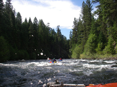
The first few miles were pleasant class I and II, the day was brilliant and the water was a deep jade color in the deeper pools. By mid-morning we found ourselves doing quite a bit of eddy hopping and log-jam portaging (approx 1 portage per mile). We slowly proceeded into a class III boulder run separated by sections of flat-water with two significant drops (class -IV & III+). One was a steeper boulder garden and the other a ledge drop; an exhilarating and exciting section (and again no pictures, too busy paddling).


Mid afternoon we came around a corner to see our first horizon line, a fairly large ledge drop of about 15' consisting of three 5' ledges. After a few minutes I decided to walk around this one, or more aptly described, hopped over rocks above the rapid and ducked under trees and pushed through brush and then scrambled some more...until I was below and could set safety for Kirk who decided to run the rapid.
Grant and I were down below and watched as Kirk seemed to slowly and easily make his way through the raging water. He makes it look so easy!
By early evening we were getting tired; the portages had taken a toll on our bodies (continuing at about 1 per mile) and our boats and the long hours on the river had me dreaming of dinner and rest. Every time it gorged up we knew there was a good rapid, and some times a log in it. LOTS more eddy hopping and boat scouting.
We were at mile 10ish of a 14-16 mile day. After passing the Little Minam River and Big Burn flat (A NICE spot where we had camped last year), we figured we could go about four more river miles before taking out above the Minam Falls to camp at a grassy meadow.
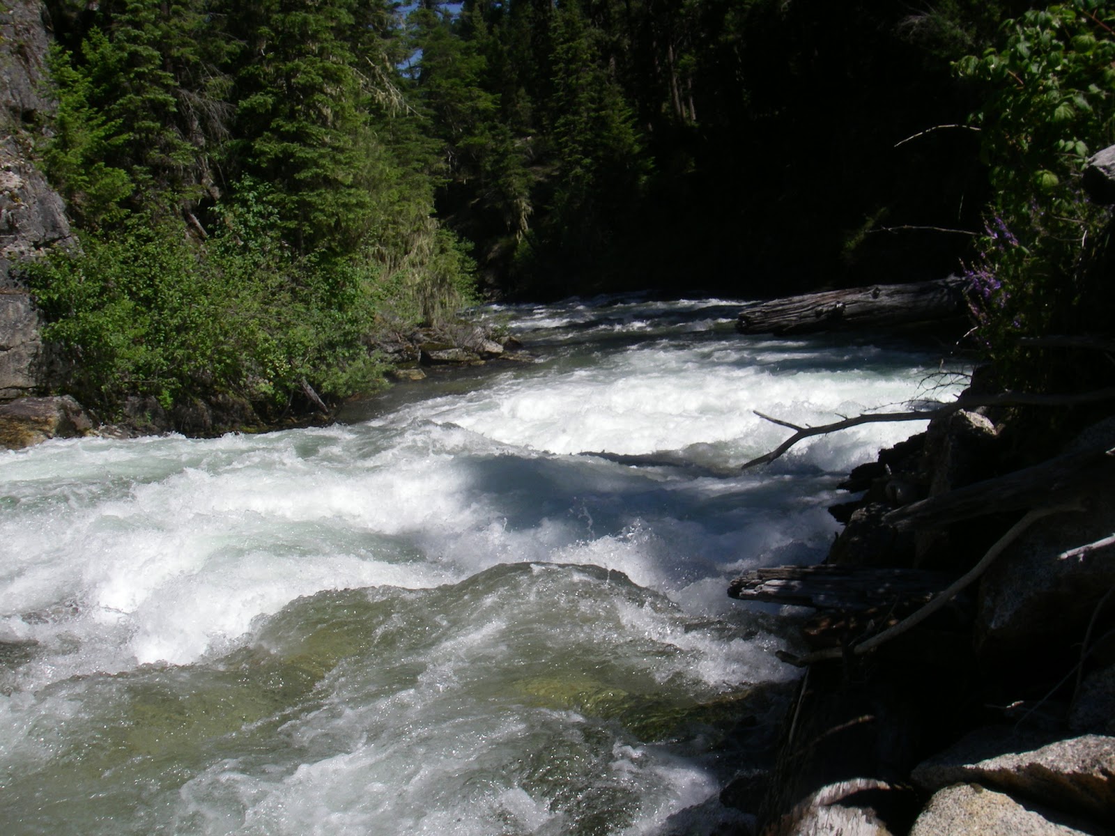
We floated, the water was quite calm and serene...until we turned a corner above a short gorge section, and another horizon line. A fallen tree had blocked the entrance to the gorge, and Grant bushwacked over to see if we had enough room to squeeze our boats through. After going Grizzly Adams on some tree-branches, he returned and reported that we would be able to pass, go Grant! Apparently we were in for 2 ledge drops and a short rapid with a big pool.
I followed Kirk into the rapid and soon we were in solid class IV water. We flew down sloping 10' drops and deep holes, and I can say I was elated not to swim in this section. Grant had described it well, but I was in a state of wanting-to-be-done and if I had listened better before we ran it, I probably would have walked around!
We all regathered below the gorge with a renewed sense of exhilaration and excitement. We surely only had a short way to go before camp, so set off on the last few miles...only to encounter yet another gorge and possible log portage.
Kirk and Grant got out to investigate...after bushwacking a good 1/8 mile they saw the log was passable and the rapid, a good class III boulder garden with an eddy on the corner. Um, that's how it started, the class III built into a class IV boulder garden ANOTHER EXTREMELY DEMANDING (scarey - my words) section ending in another horizon line.
What began as mild whitewater turned into massive hydraulics as we negotiated boulders in continuous 4-6' pour-overs, this truly is a 100'-per-mile-section as google earth would suggest. At the bottom we were all suprised and I was shaken-up by the experience. But no carnage, and after I regained my breath and pulse before going over the next horizon line, we only had to descend a short and steep rapid before we were in the clear for the rest of the float to camp.
Unfortunately Grant's GoPro had run out of batteries and we neglected to take any photos of these last two sections, Kirk and Grant are already talking about going back next year to GPS the rapids and get some footage.
The large meadow where we made our second night's camp was above the quite intimidating Minam Falls (what used to also be a splash damn, or a temporary wooden dam used to raise the water level in streams to float logs downstream to sawmills). Though Minam Falls only has remnants of a splash damn, down the corner there are still two river-wide logs from two other splash damns making deadly river-wide low-head damns/holes.
It was practically dark by the time we ate dinner and I turned in completely exhausted.
In the morning light I could almost forget my fear at the last few sections the day before, but not completely. I decided to walk the trail around the final four miles of "unknown" river and gorges before the water widens out and is much calmer at Red's. I was beaten up and bloody and enjoyed the hiking.
The water level was down to about 700 cfs, and the guys portaged this section; running Minam Falls isn't out of the question, but at this water level with three river-wide holes at the bottom of the falls you might not come out unscathed ... then getting out in time before the log splash-damns around the corner might be a much hairier situation.
The portage was easy with a game/hiking trail the whole way.


When I met Kirk and Grant at the bridge at Red's they reported a relatively easy class III section, and although I was a bit remis to miss this section, there were still 22 miles of river left to go.

We floated to the far end of the meadow and took out near the Minam River Lodge. With boats in the shade of the mid-day sun, we walked up to the lodge with hopes of cold beer.


A couple of Pale Ales and IPA's later, we left the lodge to get in a few more miles before dark.


The water was splashy and continuous class II, and after a while Grant and I switched boats. He hadn't paddled an Alpacka before, and he was paddling a self-bailing Feathercraft BayLee boat. I was intrigued by the self-bailing feature as the velcro on my Lama had become matted with moss and debris from the many portages where we were pushing and falling through dense brush; the velcro on my spray skirt was not remaining shut through the rapids and I had to constantly pull over to dump out the boat.
The BayLee was quite fun! It paddled more like an IK, I sat higher out of the water, and the floor did indeed drain. The Feathercraft is something to think about for the future.
We made camp on some prime river-front property...granted the flat spots were few and far between, but we had a long beach of rocks and a great view of the water.

We woke on our last morning and loaded up the boats for one long stretch directly to the door of the Minam River Motel. The water was calm and the day was a big improvement over last year when we had rain for most of the section.


Arriving at the Motel we were all still sore and stiff from our four days and Grant was greeted with a slew of rafts ready to launch and a busy business needing his attention. Only a slight disadvantage to living the dream!
Since we were done mid-afternoon, Kirk and I drove up the Lostine River and found a pristine camp on the water and proceeded to relax in style most of the rest of the day.

We could find only one other reference to boating this section, a group of boaters ran the section in September of 2010 with water levels around 300 cfs. Since much of what they ran would look and act completely different at the higher water flows, we weren't really sure what to expect! Grant and Kirk and I had seen different sections of the river from different points, but there are quite a few spots where gorges or overgrown brush make it difficult to see what is happening from the trail, or even when bushwacking and trying to see the river. It would be a true adventure!
We left Bend late afternoon on July 3 for the six hour drive to Minam. Rolling in about 11pm, we crashed on the lawn of the Minam River Motel (Grant's new purchase this year). In the morning we hemmed and hawwed about what to bring...hammocks? beer? Our 13 mile hike from Buck Creek Trailhead would take us over a 8,000' pass with thousands of feet of elevation gain and loss, so we tried not to make our packs unbearably heavy. It didn't work. They were still heavy.
Grant met us with his load including a very nice camera, tripod and gopro. We would have some great footage of this trip! Our point-and-shoot camera usually stays in our PFDs during the rapids. It's hard to take pictures and paddle at the same time.
Lottie, Grant's wife, shuttled us to the trailhead, and after sweating to get our packs on, we began the slow assent to Burger Pass.
 |
| Kirk and Grant on their way up the pass. |
 |
| Kirk finds snow at Burger Pass |
 |
| Grant enjoys the view |
 |
| Stunning granite mountains |
 |
| Crossing Elk Creek |
 |
| Since wearing barefoot shoes, I just walk through the water. |
 |
| Camp near the confluence of Elk Creek & Minam River |
 |
| Ready the boats! |
 |
| This is the life! |


Mid afternoon we came around a corner to see our first horizon line, a fairly large ledge drop of about 15' consisting of three 5' ledges. After a few minutes I decided to walk around this one, or more aptly described, hopped over rocks above the rapid and ducked under trees and pushed through brush and then scrambled some more...until I was below and could set safety for Kirk who decided to run the rapid.
 |
| View of the rapid from above |
By early evening we were getting tired; the portages had taken a toll on our bodies (continuing at about 1 per mile) and our boats and the long hours on the river had me dreaming of dinner and rest. Every time it gorged up we knew there was a good rapid, and some times a log in it. LOTS more eddy hopping and boat scouting.
We were at mile 10ish of a 14-16 mile day. After passing the Little Minam River and Big Burn flat (A NICE spot where we had camped last year), we figured we could go about four more river miles before taking out above the Minam Falls to camp at a grassy meadow.
We floated, the water was quite calm and serene...until we turned a corner above a short gorge section, and another horizon line. A fallen tree had blocked the entrance to the gorge, and Grant bushwacked over to see if we had enough room to squeeze our boats through. After going Grizzly Adams on some tree-branches, he returned and reported that we would be able to pass, go Grant! Apparently we were in for 2 ledge drops and a short rapid with a big pool.
 |
| If I really had been scouting I would have been ALOT more nervous about what was to come... |
 |
| Nah, can't see the massive water ahead |
We all regathered below the gorge with a renewed sense of exhilaration and excitement. We surely only had a short way to go before camp, so set off on the last few miles...only to encounter yet another gorge and possible log portage.
Kirk and Grant got out to investigate...after bushwacking a good 1/8 mile they saw the log was passable and the rapid, a good class III boulder garden with an eddy on the corner. Um, that's how it started, the class III built into a class IV boulder garden ANOTHER EXTREMELY DEMANDING (scarey - my words) section ending in another horizon line.
What began as mild whitewater turned into massive hydraulics as we negotiated boulders in continuous 4-6' pour-overs, this truly is a 100'-per-mile-section as google earth would suggest. At the bottom we were all suprised and I was shaken-up by the experience. But no carnage, and after I regained my breath and pulse before going over the next horizon line, we only had to descend a short and steep rapid before we were in the clear for the rest of the float to camp.
 |
| Below the last rapid of the day after a monstrous section |
The large meadow where we made our second night's camp was above the quite intimidating Minam Falls (what used to also be a splash damn, or a temporary wooden dam used to raise the water level in streams to float logs downstream to sawmills). Though Minam Falls only has remnants of a splash damn, down the corner there are still two river-wide logs from two other splash damns making deadly river-wide low-head damns/holes.
It was practically dark by the time we ate dinner and I turned in completely exhausted.
In the morning light I could almost forget my fear at the last few sections the day before, but not completely. I decided to walk the trail around the final four miles of "unknown" river and gorges before the water widens out and is much calmer at Red's. I was beaten up and bloody and enjoyed the hiking.
The water level was down to about 700 cfs, and the guys portaged this section; running Minam Falls isn't out of the question, but at this water level with three river-wide holes at the bottom of the falls you might not come out unscathed ... then getting out in time before the log splash-damns around the corner might be a much hairier situation.
The portage was easy with a game/hiking trail the whole way.
 |
| Minam Falls |


 |
| Looking back towards Minam Falls |
 |
| Two river-wide logs, remnants of the old splash-damns |

We floated to the far end of the meadow and took out near the Minam River Lodge. With boats in the shade of the mid-day sun, we walked up to the lodge with hopes of cold beer.


A couple of Pale Ales and IPA's later, we left the lodge to get in a few more miles before dark.


The water was splashy and continuous class II, and after a while Grant and I switched boats. He hadn't paddled an Alpacka before, and he was paddling a self-bailing Feathercraft BayLee boat. I was intrigued by the self-bailing feature as the velcro on my Lama had become matted with moss and debris from the many portages where we were pushing and falling through dense brush; the velcro on my spray skirt was not remaining shut through the rapids and I had to constantly pull over to dump out the boat.
 |
| Grant tries out the Alpacka |
We made camp on some prime river-front property...granted the flat spots were few and far between, but we had a long beach of rocks and a great view of the water.

We woke on our last morning and loaded up the boats for one long stretch directly to the door of the Minam River Motel. The water was calm and the day was a big improvement over last year when we had rain for most of the section.

 |
| We paced the horseback rider for some time. |


 |
| Kirk surfs |
 |
| Approaching Minam River Motel |
Since we were done mid-afternoon, Kirk and I drove up the Lostine River and found a pristine camp on the water and proceeded to relax in style most of the rest of the day.

Subscribe to:
Posts
(
Atom
)